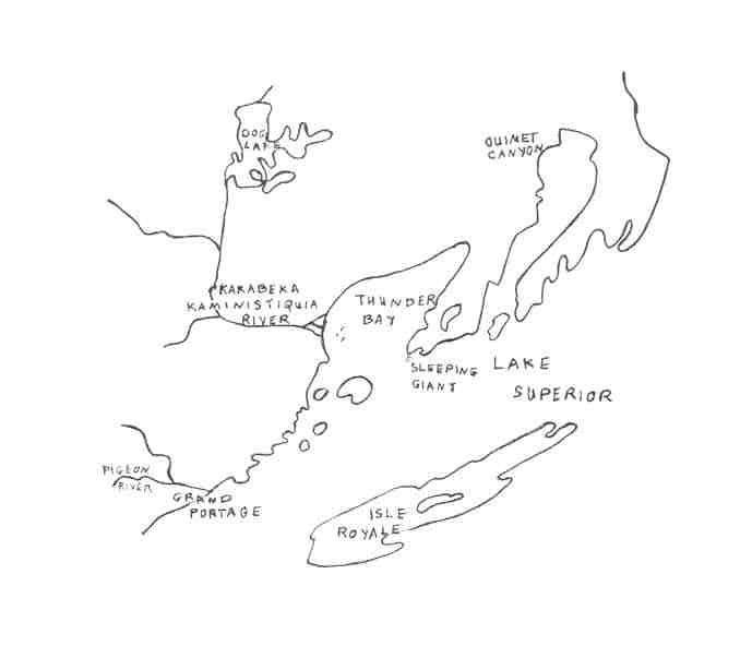
 The north west
shore of Lake Superior, the largest lake on earth, is rich with spectacular
landmarks carved by nature.
The north west
shore of Lake Superior, the largest lake on earth, is rich with spectacular
landmarks carved by nature.
The Ojibway
In the year 1610 A.D., these natural wonders had
yet to be seen by European eyes. To the east, Samuel de Champlain had reached
Lake Huron; to the north, Henry Hudson had landed on the shore of Hudson's
Bay; but Étienne Brulé, who is officially considered to be
the first European to see Lake Superior, had gone no further than the great
lake's south east shore by 1622. The area was sparsely inhabited
by small bands of Cree, Sioux and Ojibway, and the plentiful wildlife of
the boreal forest.
According to oral tradition he Ojibway, an
Algonkian people, had begun moving west in the late 1500s, to escape the
Iroquois. As they moved they split into two groups, following the north
and south shores of the great lake. The northern group reached the
bay on the north west shore, and settled in the area, camping in seasonal
sites on lakes and rivers where they found the staples to sustain life.
They hunted moose, caribou, beaver, and smaller game and birds, using snares
and bows and arrows. They fished in lakes and rivers thick with diverse
species. They gathered maple syrup, berries and wild rice.
Animal hides and birchbark were used to make clothing, shelter, canoes
and baskets. They made tools were out of stone. (Dawson, 1983)
The boreal forest surrounding their waterside encampments
was dominated by coniferous trees: black and white spruce, jackpine, tamarack
and balsam fir, along with two deciduous species: white birch and aspen.
On the south slope of the mountain, sugar maples grew at their extreme
northern range. White and Norway pine thrived in numerous stands
south of the Kaministiquia and in small patches to the north and east.
From time to time fire started by lightning and
fuelled by dead trees and branches and the resins, oils, gums and waxes
that they contain, would ignite an area of mature forest. (Addison,
1994) Gradually a new, reinvigorated forest would regenerate from the ashes
of the old, nurturing birds native to the boreal forest such as white-winged
crossbills, boreal owls and northern three-toed woodpeckers.
Ojibway-Sioux Conflict
The Ojibway people had no common political system.
They followed traditions developed for living with the natural world.
Certain individuals were shamans or medicine men who tried to control the
good and evil spirits around them. Everyone had the opportunity to
form a relationship with a manitou or guardian spirit, usually contacted
in dreams. (Dawson, 1983)
Just as the they had been
displaced by the Iroquois, so the Ojibway put pressure on the Cree to the
north and the Sioux to the west. In 1659, Radisson and Groseillers
found that the Ojibway avoided the area that is now Minnesota because it
was the land of the Sioux. Early French explorers found evidence
of the Sioux in the area they named Dog Lake, after the dog images the
Sioux revered, which they found in the area. Further west, the Sioux
built a more practical creation: a portage to travel around the falls on
the Pigeon river, known to them as Nantakouagane. They also hunted
buffalo, whose primitive range was north of a line beginning at the western
extremity of Lake Superior, north west to the south shore of Lake of the
Woods.Yet by 1730 the Ojibway were living at Rainy Lake, and had advanced
into Minnesota.
A major battle is said to
have taken place at Crooked Rapids on the Kaministiquia about the year
1620. The legend of Greenmantle, the Ojibway woman who tricked the
Sioux warriors by leading their canoes over the falls at Kakabeka, also
dates from this time. Even before any Europeans actually reached the north
west, these native people had come into possession of metal knives and
axes through trade with the French and native intermediaries to the east.
This trade was a major factor in giving the Ojibway the upper hand in their
conflict with the Sioux, and after 1620 the Ojibway pushed the Sioux to
the west of the Thunder Bay area and held them there.
In 1678 Du Lhut was sent to
end the Ojibway-Sioux war which was interfering with trade, but hostilities
continued for many years. In 1736 a group of La Verendrye's adventurers
were attacked by Sioux on an island in Lake of the Woods. The next
year the killing of an Ojibway family by Sioux near Lake Superior provoked
massive retaliation. A three day battle took place at what is now
Big Falls, north east of Red Lake in Minnesota. The year 1757 marks
the last full scale Ojibway-Sioux war in Northwestern Ontario, and by about
1770 the Ojibway conquest was complete. The history of Ojibway-Cree
conflict is less dramatic, but by the end of the eighteenth century the
Cree had been gradually displaced from their sites in the Lake Nipigon
area.
A Historical Mystery
The identity of the first
Europeans to visit the north west shore of the great lake is uncertain.
Pierre-Esprit de Radisson and Médart Chouart, Sieur des Grosielliers
may have reached the mouth of the Kaministiquia River in the winter of
1622, but the exact route these explorers and fur traders followed is not
clear. They had no maps, and their descriptions of their travels
and the ice-clogged bay they visited are vague. Until recently a
cairn in Gore Park in front of St. Andrew's church in Thunder Bay, proclaimed
this version of history.
It is known that Radisson
landed on Isle Royale in 1661, naming it in honour of a royal wedding taking
place in Paris. The first verified European visitor to the mouth
of the Kaministiquia was Daniel Greysolon Du Lhut, who built the trading
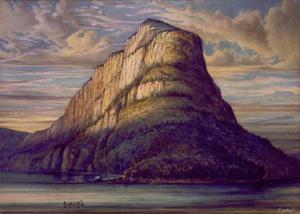
post of Caministigoyan there in 1678. According to legend it was
about this time, with the arrival of the first whites, that Nanabijou displeased
Kitche Manitou and began his endless sleep.
Toward the Western Sea
Slowly but steadily the Europeans
moved west, driven by two pioneering desires: wealth and adventure.
The former was achieved by trading for furs; the latter, by searching for
the Western Sea - the route to China and Japan. To early adventurers, trading
was the means to support the quest for this sea, which they were always
certain lay just beyond the setting sun, as they canoed and portaged further
and further west. By 1688 Jacques de Noyons had found the centuries
old canoe and portage route used by the Sioux and later the Ojibway: up
the Kaministiquia, portaging around the steep falls and across the height
of land to the Savanne River, Rainy River, Lake of the Woods, and on to
the west.
- copyright B.C.J. Yurkoski, January 2001
Keeping Ontario's Natural Wilderness
Forgotten but not Gone: the Great Trees of Thunder
Bay
BIBLIOGRAPHY
Addison, Bill. "Born to Burn". Seasons, Summer 1994.
Bertrand, J.P. Timber Wolves: Greed and Corruption in Northwestern Ontario's Timber Industry: 1875-1960. Thunder Bay Museum Society, 1997.
Dawson, K.C.A. A Prehistory of Northern Ontario. The Thunder Bay Historical Museum Society. 1983
La Verendrye: Journals and Letters.
Mauro, Joseph. Thunder Bay: a History. Lehto Printers, 1981.
Wightman, W. Robert and Nancy M. The Land Between: Northwestern Ontario Resource Development, 1800 to the 1900s. University of Toronto Press, 1997.
Wilkins, Charles. Breakfast at the Hoito and
other Adventures in the Boreal Heartland. Natural Heritage/Natural
History Inc., 1997.